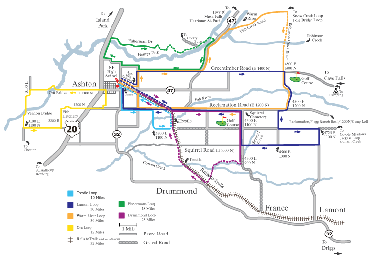
Lamont Loop - 30 miles
This loop travels 10 miles east on Greentimber/Cave Falls Road (1400N), turns south for 3 miles on 4500E, crosses Fall River, turns east on 1100N t

Bicycle routes on this map use lightly traveled state and county roads around Ashton. Cyclists must comply with all traffic laws, and use special caution on Hwys 32 and 47. Some routes use the Ashton-Tetonia Trail, a gravel/dirt trail open to bikes and featuring two scenic railroad trestles crossing Fall River and Conant Creek.
These routes begin in Ashton; parking is available at the Ashton Community Center, the North Fremont High School parking lot or the trailhead of the Ashton-Tetonia Trail one mile east of Ashton.
This loop travels 10 miles east on Greentimber/Cave Falls Road (1400N), turns south for 3 miles on 4500E, crosses Fall River, turns east on 1100N t
This loop travels east 7 miles on the Reclamation/Flagg Ranch Road (1200N), turns south at the Squirrel Cemetery (4300E) for three miles, turns wes
This loop follows Fisherman Drive from Hwy 20 east along the north bank of the Henry’s Fork (some gravel), crosses Henry’s Fork at Stone Bridge, re
This loop travels west of Ashton on the Fort Henry Byway (1300N), turns south at the ‘T’, crosses the Henry’s Fork at Ora and Vernon bridges, turns
This loop follows 1400N and Hwy 47 to the Warm River campground, turns east onto Fish Creek Road, turns right (south) on FS 241, a gravel road cros
This loop follows Hwy 32 south of Ashton for one mile, turns east on the Reclamation/Flagg Ranch Road, turns south at 3800E, crosses Fall River, tu